Research Areas & Outputs

A grid-based overview of my research across GeoAI, flood inundation mapping, hydroinformatics, remote sensing, spatial data science, and open-source geospatial software. Each research area links to a short detail page with figures, context, and related outputs.

15+
Publications
15+
Presentations
4+
Open Research Datasets

Explore by Research Theme

These cards act as the main entry points into the research. Each one connects the problem, methods, figures, publications, datasets, and software where relevant.

Surrogate modeling for flood inundation mapping
GeoAIPrimary

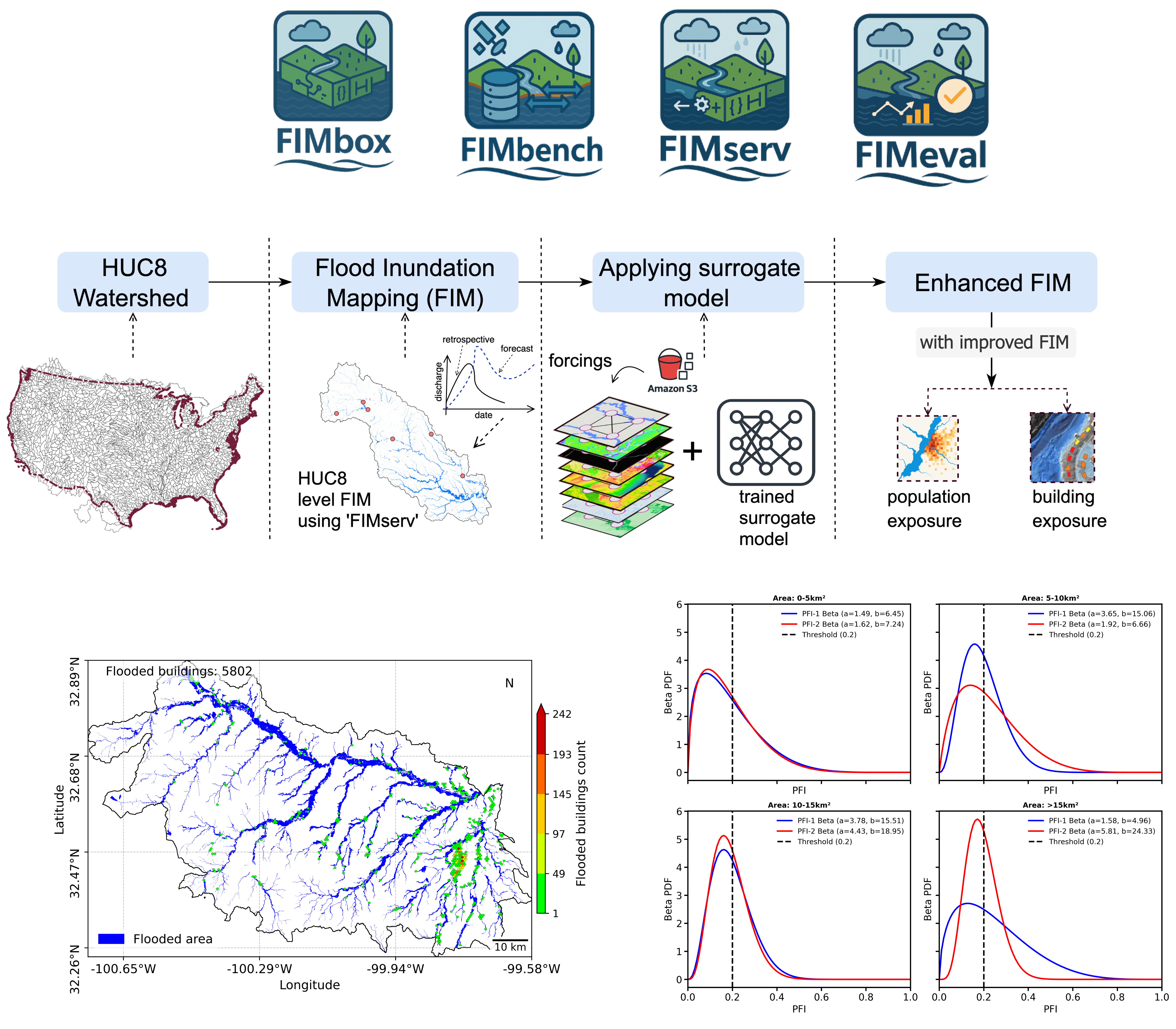
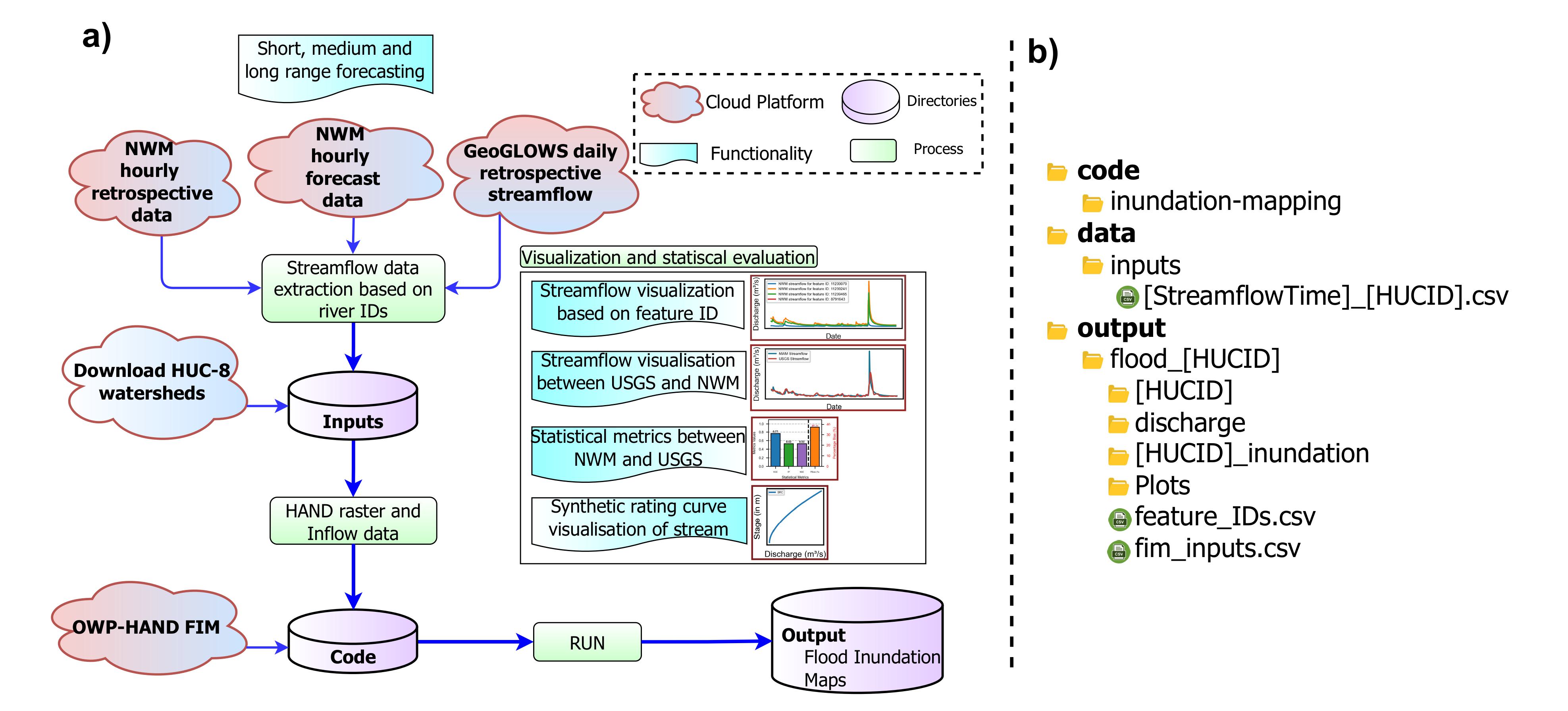
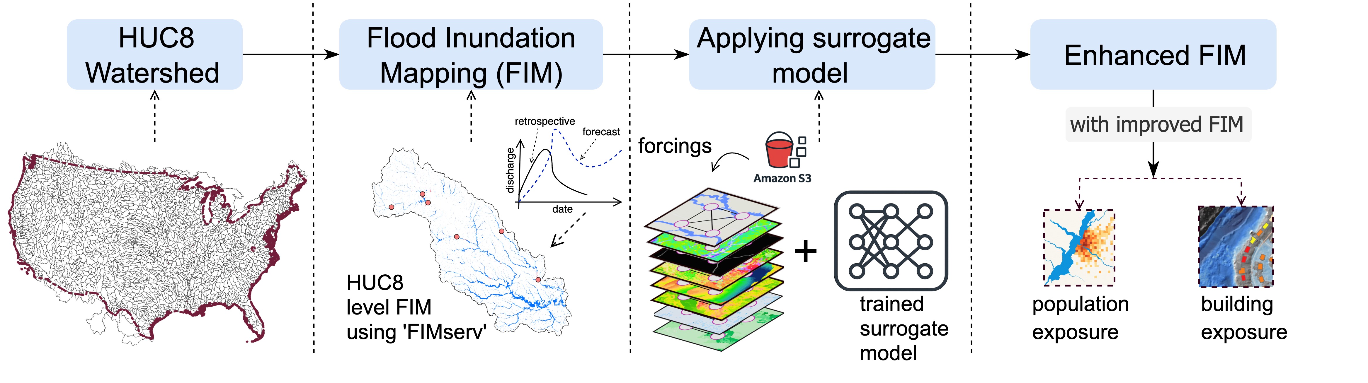
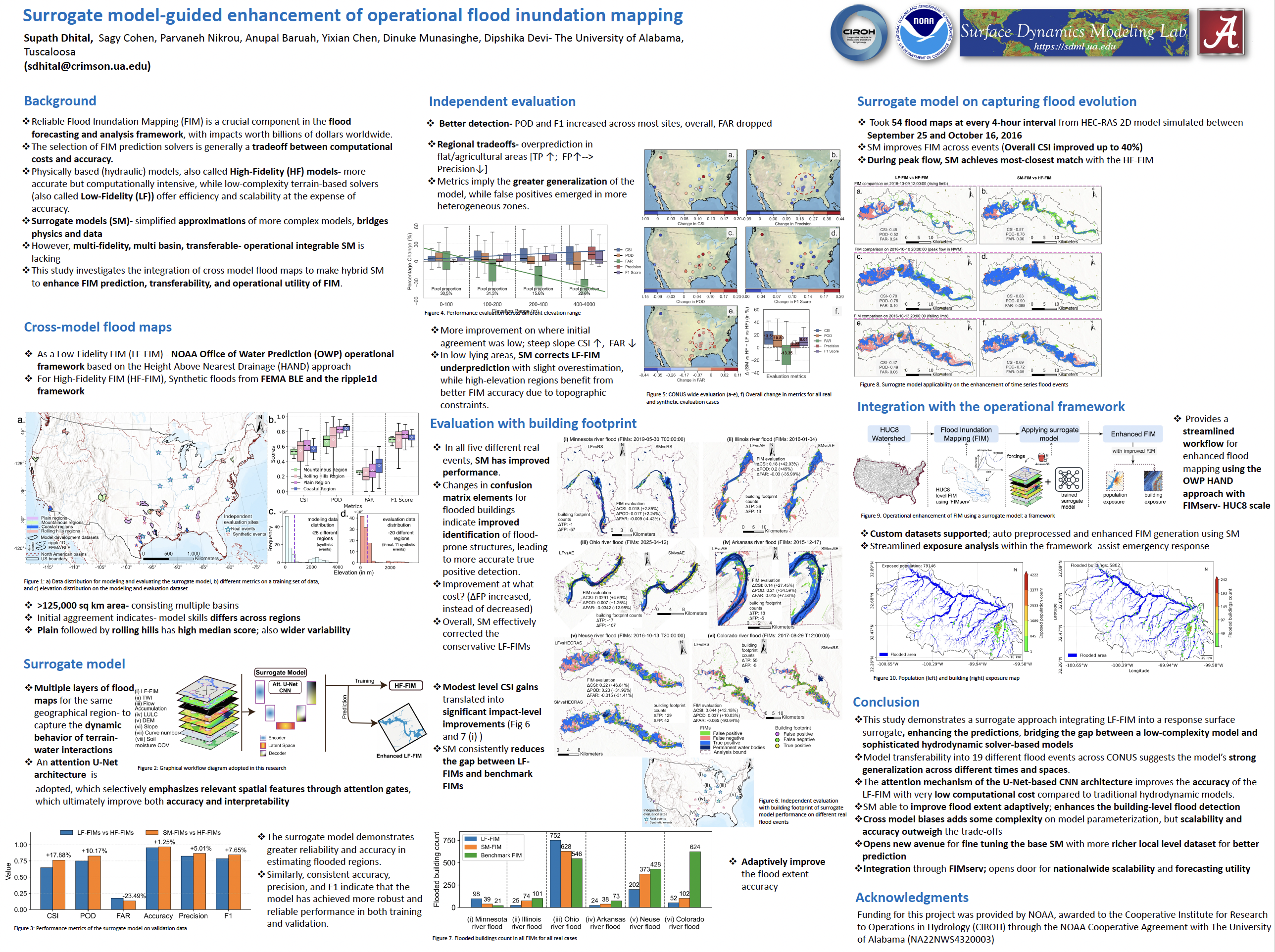
GeoAI for Flood Inundation Mapping

  • Physics-aware surrogate ML models for faster, more accurate flood mapping
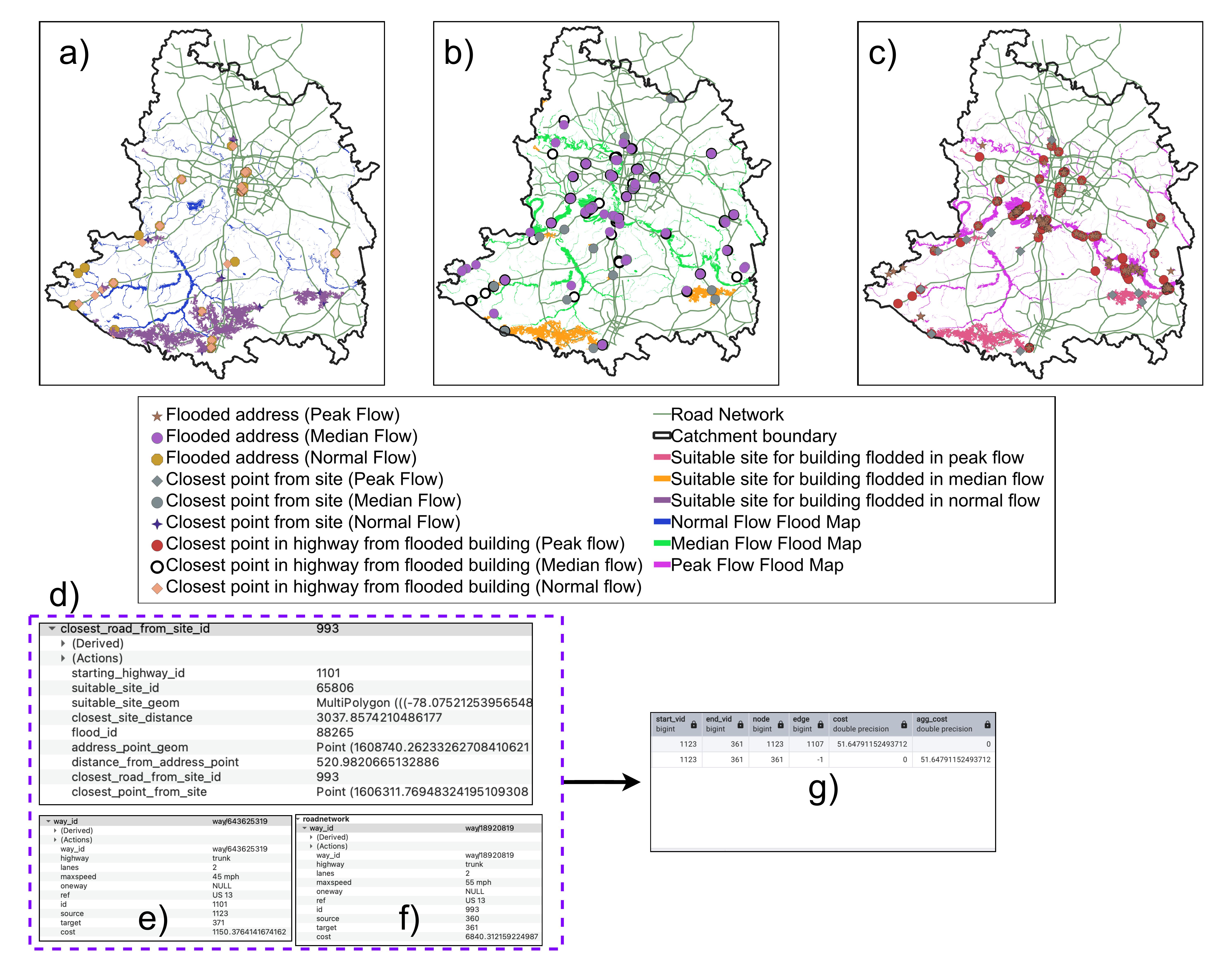
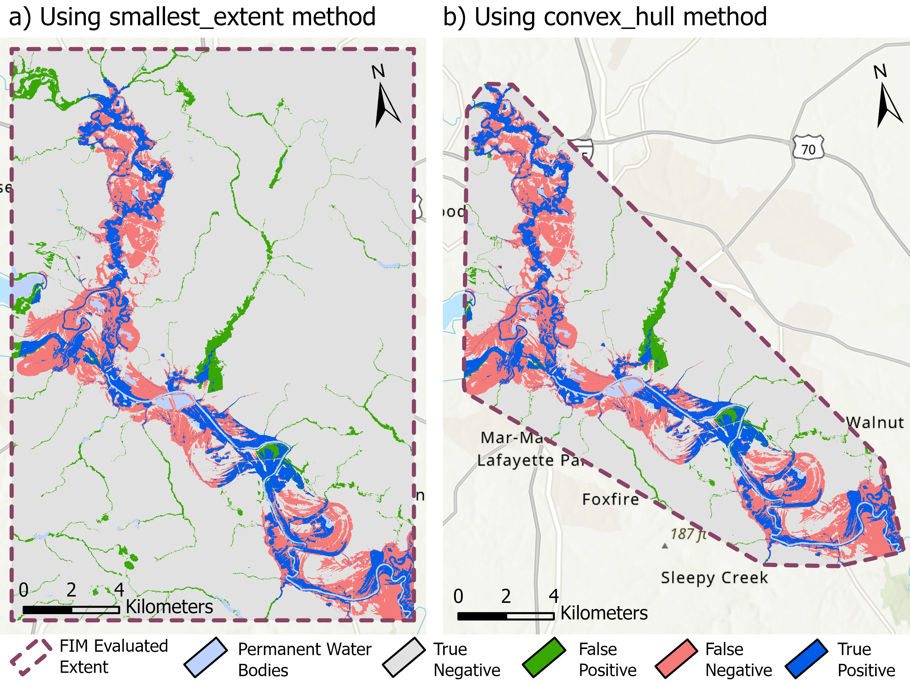
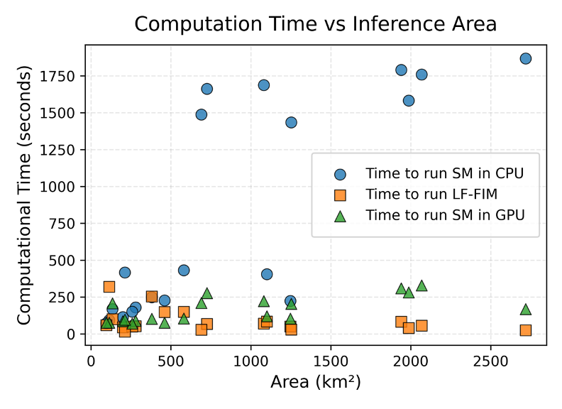
  • Hybrid AI pipeline achieving 35% accuracy gain and 10,000× speed-up over hydraulic baselines
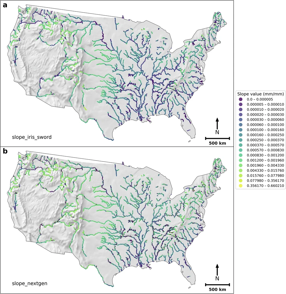
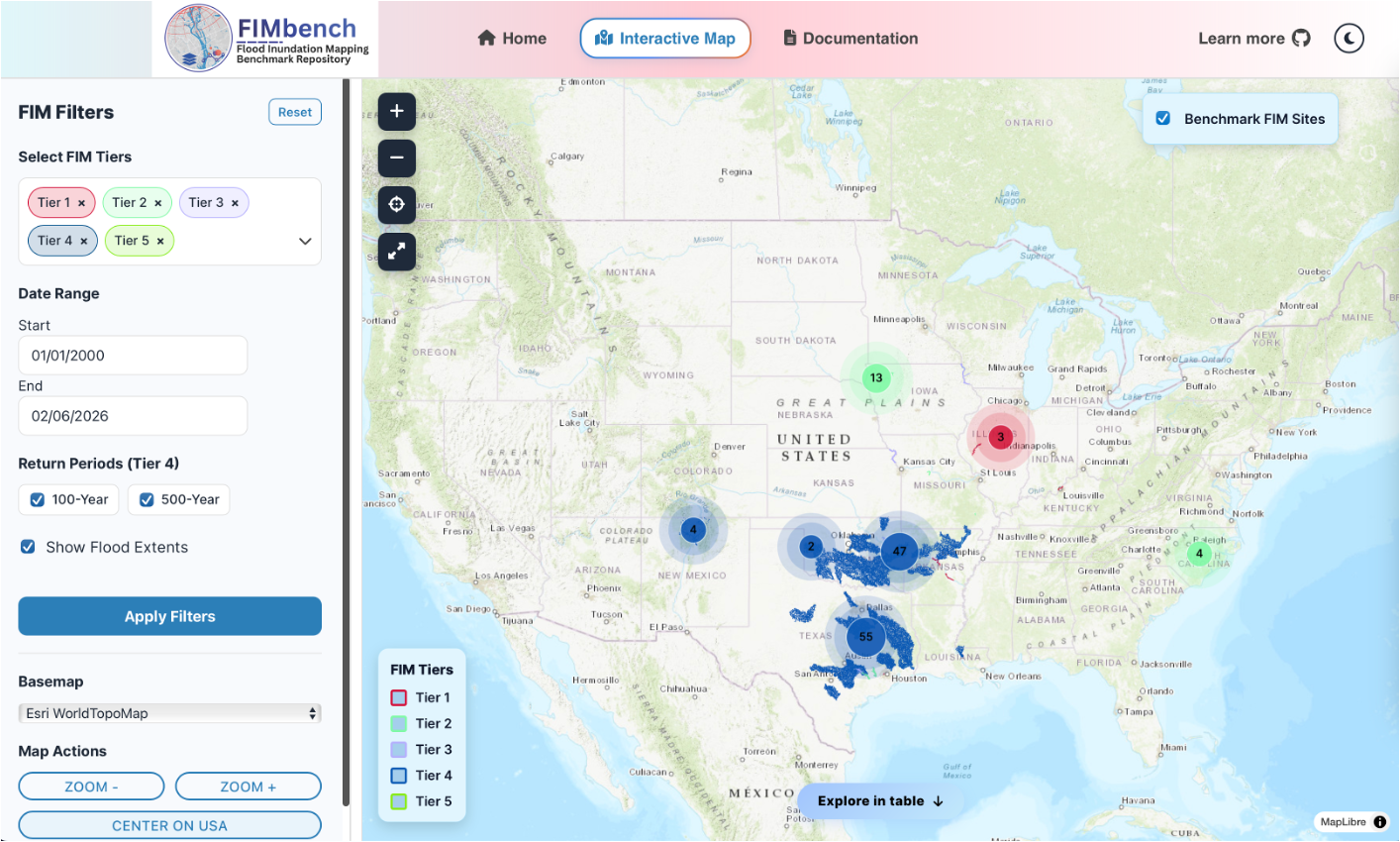
  • Scalable hydrologic decision support across national HAND-FIM frameworks
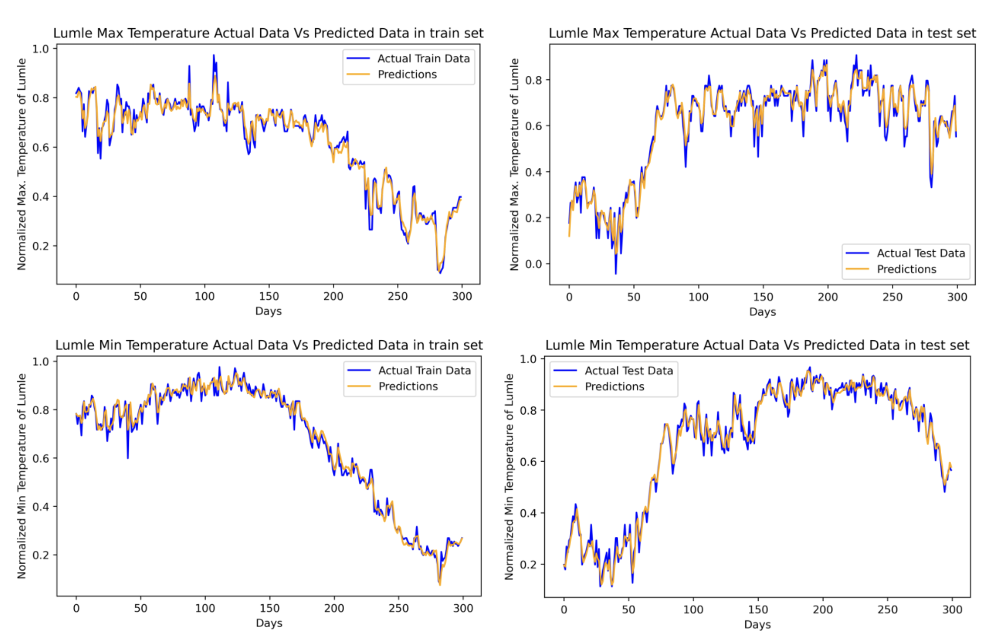
  • Deep learning for weather and hydrologic time-series forecasting
GeoAISurrogate ModelingFlood Mapping
Read more
Operational FIM software suite
SoftwareActive

Operational FIM Software & Evaluation

  • FIMbox — modular open-source testbed for configurable FIM simulations and benchmarking
  • FIMserv (40K+ downloads) — FIM-as-a-service across NOAA OWP HAND-FIM networks
  • FIMeval (15K+ downloads) — standardized evaluation framework with reproducible metrics
  • FIMbench — benchmark dataset repository and interactive Streamlit comparison app
FIMboxFIMservFIMeval
Read more
SWOT river slope and remote sensing data
Remote SensingData

Remote Sensing Hydrodata

  • ICESat-2 derived river slope dataset adopted by NOAA OWP for operational FIM
  • Global monthly reach-level water surface slopes from SWOT satellite (Zenodo)
  • Vegetation, terrain, and hydrography products for geospatial water modeling
  • UAV orthophoto generation, LiDAR processing, and field survey integration
SWOTICESat-2Raster Data
Read more
Infrastructure vulnerability and risk assessment
HydroinformaticsApplied

Hydroinformatics & Decision Support

  • PostgreSQL/PostGIS spatial databases for flood risk network analysis and routing
  • Dynamic evacuation framework for real-time route optimization under changing flood conditions
  • WebGIS dashboards (ArcGIS Online, Google Earth Engine, Leaflet, Streamlit) for risk communication
  • Pluvial flood index design and validation for NextGen Water Modeling Framework
PostGISWebGISAutomation
Read more

Selected Publications, Datasets & Presentations

A curated collection of peer-reviewed publications, benchmark datasets, and conference presentations. Each research output cross-references related papers, tools, datasets, and projects to provide complete context and access.

Thumbnail for Orthophoto Generation Using UAV
Journal2023
Orthophoto Generation Using UAV: A Case Study of Pashchimanchal Campus, Pokhara
Dhital, S. and Lamsal, K.
Geospace · Vol III · 2023
Thumbnail for CSDMS 2026 surrogate modeling presentation
Conference2026
Enhancement of low-fidelity operational flood inundation mapping through surrogate modeling
Dhital, S., Cohen, S., Nikrou, P., Baruah, A., Chen, Y., Munasinghe, D., and Devi, D.
Community Surface Dynamics Modeling System (CSDMS) 2026, Minneapolis, MN
Thumbnail for AGU 2025 CNN surrogate modeling poster
Conference2025
Convolutional Neural Network Surrogate Modeling of Flood Inundation Predictions for the United States Operational Hydrological Forecasting Framework
Dhital, S., Baruah, A., Nikrou, P., and Cohen, S.
American Geophysical Union (AGU) 2025, New Orleans, LA
Thumbnail for AGU 2024 NOAA HAND-FIM enhancement poster
Conference2024
Enhancement of the NOAA Flood Inundation Mapping Framework (OWP HAND-FIM) through Surrogate Modeling
Dhital, S., Baruah, A., Nikrou, P., and Cohen, S.
American Geophysical Union (AGU) 2024, Washington, D.C.
Thumbnail for ALWRC 2024 surrogate modeling poster
Conference2024
A surrogate modeling approach for the enhancement of the NOAA operational Flood Inundation Mapping framework (OWP HAND-FIM)
Dhital, S., Baruah, A., Nikrou, P., and Cohen, S.
Alabama Water Resources Conference (ALWRC) 2024, Orange Beach, AL
Thumbnail for CIROH 2024 OWP HAND-FIM vs HEC-RAS poster
Conference2024
A Detailed Comparison between OWP HAND-FIM and HEC-RAS Predictions
Dhital, S., Baruah, A., Nikrou, P., and Cohen, S.
CIROH Developers Conference 2024, Salt Lake City, UT
Thumbnail for AGU 2025 FIM evaluation presentation
Conference · Co-author2025
Toward Robust Large-scale Evaluations of Flood Inundation Predictions
Cohen, S., Devi, D., Munasinghe, D., Baruah, A., Tian, D., Dhital, S., and Liu, H.
American Geophysical Union (AGU) 2025, New Orleans, LA
Thumbnail for AGU 2025 SWOT river slope presentation
Conference · Co-author2025
Global-Scale Analysis of River Slope Monthly Variation Based on the SWOT River Vector Data Product
Chen, Y., Dhital, S., Cohen, S., Baruah, A., and Devi, D.
American Geophysical Union (AGU) 2025, New Orleans, LA
Thumbnail for AGU 2025 FIMserv presentation
Conference · Co-author2025
FIMserv v.1.0: A Tool for Streamlining Flood Inundation Mapping (FIM) Using the United States Operational Hydrological Forecasting Framework
Baruah, A., Dhital, S., Cohen, S., Tran, T.N.D., Elhaddad, H., Watts, C.L., Devi, D., Chen, Y., and Pruitt, C.
American Geophysical Union (AGU) 2025, New Orleans, LA
Thumbnail for AGU 2025 FIMeval framework presentation
Conference · Co-author2025
A Framework for the Evaluation of Flood Inundation Predictions Over Extensive Benchmark Databases
Devi, D., Dhital, S., Munasinghe, D., Cohen, S., Baruah, A., Chen, Y., Tian, D., and Pruitt, C.
American Geophysical Union (AGU) 2025, New Orleans, LA
Thumbnail for AGU 2025 pluvial flooding NextGen presentation
Conference · Co-author2025
Towards Representing Pluvial Flooding within NOAA's NextGen Modeling Framework
Bhattarai, Y., Dhital, S., Sauda, S., Abdelkader, M., Frame, J.M., and Temimi, M.
American Geophysical Union (AGU) 2025, New Orleans, LA
Thumbnail for AGU 2025 infrastructure vulnerability presentation
Conference · Co-author2025
Assessing Infrastructure Vulnerability and Evacuation Routes to Flooding Using Spatial Database Management: A Case Study of City of Mobile, Alabama
Haque, M.M., Shao, W., Dhital, S., and Li, D.
American Geophysical Union (AGU) 2025, New Orleans, LA
Thumbnail for HEPEX 2025 FIMServe Python package presentation
Conference · Co-author2025
FIMServe: A Python Package for Operational Flood Inundation Mapping across CONtiguous United States
Baruah, A., Dhital, S., Cohen, S., Tran, T.N.D., Elhaddad, H., Watts, C.L., Devi, D., Chen, Y., and Pruitt, C.
HEPEX Conference, The University of Alabama 2025, Tuscaloosa, AL
Thumbnail for CIROH 2025 FIM evaluation presentation
Conference · Co-author2025
Evaluating Flood Inundation Mapping Predictions Using Large-Scale Benchmark Datasets
Devi, D., Dhital, S., Munasinghe, D., Tian, D., Cohen, S., Baruah, A., and Chen, Y.
CIROH Developers Conference 2025, Burlington, VT
Thumbnail for HEPEX 2025 automated FIM evaluation framework
Conference · Co-author2025
A Python-Based Automated Framework for Evaluating Flood Inundation Mapping Predictions Across Diverse Benchmark Datasets
Devi, D., Dhital, S., Munasinghe, D., Baruah, A., Tian, D., Nikrou, P., and Cohen, S.
HEPEX Conference, The University of Alabama 2025, Tuscaloosa, AL