Hello, I'm Supath Dhital
Geospatial Water Resources Researcher & Developer
I design scalable GIS, spatial data science, and hydroinformatics solutions that connect water resources science, GeoAI, software development, and decision support. My work spans flood modeling tools, geospatial data pipelines, WebGIS applications, model automation, and reproducible systems for water management, disaster preparedness, and climate resilience.
Bridging Geospatial Science & AI
I work across geospatial data, water science, and AI to build practical digital solutions for research, operations, planning, and decision support.
My work combines GIS, spatial data science, GeoAI, WebGIS, cloud automation, spatial databases, surveying workflows, and scientific programming to turn complex location-based data into reliable tools, maps, models, and web systems.
Geospatial AI
GeoAI and remote sensing workflows for spatial insight.
AI for Water Science
ML models for hydrology, flood mapping, and water systems.
WebGIS & Spatial Database
Web maps, dashboards, portals, and PostGIS backends.
Cloud Computing & Automation
Python pipelines, cloud storage, and workflow automation.
Featured Software & Tools
All tools are open-source and publicly available, supporting researchers, public agencies, and emergency managers.
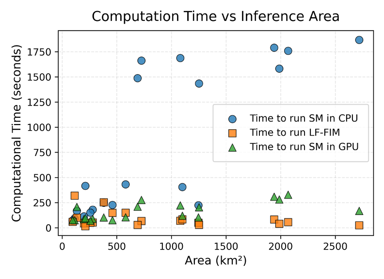
Modular open-source testbed for Flood Inundation Mapping research, model comparison, workflow automation, and reproducible FIM experiments.
Evaluation framework for flood-inundation predictions across extensive benchmark databases. Enables large-scale comparative assessment of FIM models.
Modular Flood Inundation Mapping (FIM) platform using NOAA OWP HAND-FIM. Streamlines FIM generation across CONUS for research and operational use.
Recent Publications